Thunderstorms and strong winds are set to rage overnight in parts of the UK, after London endured flash flooding caused by more than half a months’ worth of rainfall in a single night.
The Met Office issued weather warnings in the south of England and Wales on Thursday night and cautioned that some flooding of homes and businesses is likely as a result of the heavy, thundery storms.
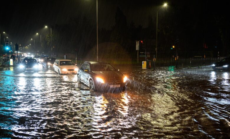
People could face travel disruption and delays, with the storms forecast to bring 30 to 40mm of rain in just a few hours – the same amount which saw residents in parts of Greater London wake on Thursday to flooded roads and transport issues.
Once the storms clear southwards, however, “most of the UK should definitely see at least a glimmer of sunshine” on Friday, Met Office forecaster Ellie Wilson told The Independent.
The national forecaster has issued a yellow weather alert lasting from 3pm until midnight on Thursday covering Cornwall, north Devon and south Wales, and another is in place across much of England’s south coast from 8pm until 6am.
“Within those two warning areas, thunderstorms could bring between 30 to 40mm of rain in a couple of hours, so quite a bit of rain – and there’s a chance of hail and lightning in there as well,” Ms Wilson said, adding: “The next couple of hours are the main rough period of those heavier thunderstorms.”
The Met Office has warned that some buildings will probably be damaged in the storms and that power cuts are likely.
“There is probably a risk [of damage to buildings] from the lightning, but also it could be – especially in the South West – due to the gusts of wind as well,” said Ms Wilson.
The amount of rainfall expected in just a couple of hours could cause localised flooding, “especially as we’ve had quite a bit of rain in the past couple of days”, the forecaster warned.
The Environment Agency has issued nearly 30 flood alerts – meaning “flooding is possible” – in the south of England, as well as eight stronger flood warnings in Kent and Sussex, where residents are urged to “act now”.
Ms Wilson advised people only to make necessary journeys, particularly at the coast where the winds may be strongest and could cause some swells.
“Driving conditions could be affected by those heavier thunderstorms, so visibility can be decreased and localised surface water flooding could cause some travel disruption as well. There could also be some delays to public transport, so just keep up to date with the latest weather forecast and local services to check for any delays,” Ms Wilson said.
“It’s not the most pleasant conditions to be in with heavy winds and strong rain. I’d avoid it if it was me,” she added.
A separate yellow weather warning for rain, stretching from Portsmouth to Canterbury and parts of London, was in place until 3pm on Thursday, and some train services were hit by cancellations and delays due to flooding.
A total of 64mm of rain fell in Horsmonden in Tunbridge Wells, the Met Office said, with more than 50mm in 24 hours in other areas. The top rainfall totals recorded in the 12 hours to 8am on Thursday were at Kew Gardens in west London (42mm) and Odiham in Hampshire (40.2mm).
This week’s heavy rainfall was caused by a “stalling” weather front which prolonged the downpours, said Ms Wilson, adding: “It was quite a lot of rain in one go.
“But because we’re only at the 3rd of the month, it’s hard to say whether we’re going to be having a really wet November or how that could impact the rest of the month.”
Once the storms clear, however, Friday “will be a nicer, drier day compared to what we’ve just seen”, with sunny spells across the UK and just few showers towards the north, Ms Wilson said, adding: “So that’s something to look forward to.”
“But then more unsettled weather is heading our way towards the weekend – so the best chance of seeing some sunshine is tomorrow before the weekend.”
Commuters with umbrellas in Westminster in London